Dart Mining NL (ASX:DTM) continues to explore copper-gold porphyry opportunities at its flagship Granite Flat property in northeast Victoria.
The explorer is currently executing deep diamond drilling at the project and recently fielded some strong, multi-commodity results from two previous drill holes.
A soil sampling infill program is also underway, with just under half of the planned 4,170 samples collected and analysed to date.
'Significant milestones' in project development
Dart Mining chair James Chirnside said: “Dart’s flagship Granite Flat copper-gold porphyry project continues to progress very well.
“Ongoing deep diamond drilling of geophysical targets and an expansion in the soil sampling program represent significant milestones in the development of this very encouraging project.
“With much of the early-stage exploration activities soon to be completed, we expect to continue the deep diamond drilling campaign on multiple highly prospective IP targets that were identified from last year’s geophysical survey.”
Deep diamond drilling
Dart has tapped Territory Drilling to execute three holes, spanning 1,200 metres, at the Granite Flat project.
The holes are doubling down on induced polarisation (IP) targets 300 to 450 metres below the surface.
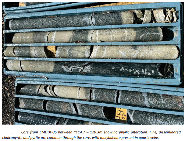
Drilling is well underway, currently roughly 170 metres into hole EMDDH006, which targets an IP anomaly at around 350 metres down-hole.
Once EMDDH006 is complete, drilling will progress to a further two holes on significant IP targets identified through Dart’s 2021 field geophysics program.
Diamond drilling at shallow targets
The first four holes of Dart Mining’s in-house diamond drilling program at Granite Flat targeted vein-style silica-sulphide mineralisation and follows up on promising intersections identified through the 2020 rotary air blast drilling program.
Results have since come back for the third and fourth holes in the campaign.
Assays from EMDDH003 include:
➢ 19.33 metres at 0.72 g/t gold and 0.11% zinc from 72.0791.40 metres, including 4.42 metres at 1.2 g/t gold and 1 metre at 0.74% zinc; and
➢ 12.93 metres at 0.29% copper and 13.2 g/t silver from 72.0785.00 metres, including 2 metres at 26.3 g/t silver and 2 metres at 37.5 g/t silver and 2 metres at 220 ppm molybdenum.
Assays from EMDDH004 include:
➢ 17.3 metres at 1.2 g/t gold and 2.9 g/t silver from 4663.3 metres, including 2.3 metres at 5.6 g/t gold and 6.3 metres at 5.6 g/t silver; and
➢ 18.3 metres at 0.24% copper from 4563.3 metres, including 6.3 metres at 0.44% copper.
EMDDH004 was designed as a twin to hole EMPRAB28, which contained a high-grade intersection of 19 metres at 9.4 g/t gold, 19 g/t silver and 0.61% copper, including 3 metres at 41.1 g/t gold, 92.9 g/t silver and 1.52% copper and terminated in mineralisation.
A fifth hole, EMDDH005, targeted a soil copper-gold anomaly coincident with a small, shallow IP anomaly. Assays are expected in the coming weeks.
Resampling historical core
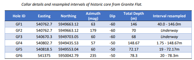
In addition to generating new diamond core, Dart has obtained historical core from holes GF1 to GF6, which were drilled at Granite Flat between 1987 and 1989 by Meltech Ltd.
Previously, these cores were only selectively sampled, despite showing intersections of unsampled disseminated sulphide associated with potassic alteration and stringer vein silica-chalcopyrite-pyrite mineralisation.
Dart Mining is currently reprocessing this core to obtain maximum value from all available sources in its assessment of the Granite Flat project.
Core from four of the six holes recovered by Dart Mining have been resampled and submitted for assay.
Soil sampling program
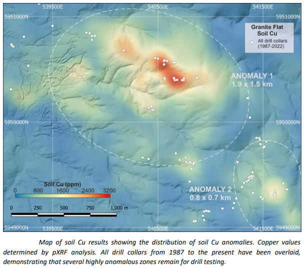
An expanded soil sampling program across a 50-metre grid at Granite Flat is well underway, with 1,926 samples collected and analysed of a planned 4,170.
The soil program spans the original project area and extends beyond to cover remanent magnetism and gravity anomalies identified in reprocessed airborne data.
Soil samples are collected by field teams, then dried and analysed by portable X-ray Fluorescence (pXRF), providing a rapid and cost-effective sampling strategy.
So far, anomalous soil copper values up to 0.32% have been identified, and at the present extent of the sampling program, a soil copper anomaly spanning 2.5 by 1.9 kilometres has been identified, with a second, smaller 0.8 by 0.7-kilometre copper anomaly remaining open to the southeast.
The soil sampling program is ongoing, expected to close out in early April.
The second, smaller soil anomaly will be further investigated and closed out to the southeast.
In the meantime, additional sampling to the north of the current area will also be undertaken to assess targets identified in airborne geophysics datasets.
LiDAR interpretation
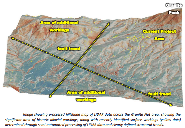
Following the successful application of LiDAR data collection and interpretation on Dart’s nearby Dorchap Range Lithium project, a 28-square-kilometre area of LiDAR data coverage across the Granite Flat project has been processed by Geocloud Analytics.
Through the application of semi-automated machine learning and AI algorithms, more than 390 historic pit and shaft workings have been identified across the project area, giving Dart further insight into Granite Flat’s historical development.
Additionally, LiDAR interpretation provides scope to the substantial alluvial footprint of the area, with 276 hectares of alluvial workings across the flats mapped in detail.
This area excludes a similarly notable area of alluvial workings south of the Granite Flat project in the Lightning Creek area.
The extent of these alluvial workings provides a strong indication as to the prospective gold endowment of the catchment area, which is largely encapsulated by the Granite Flat project footprint.